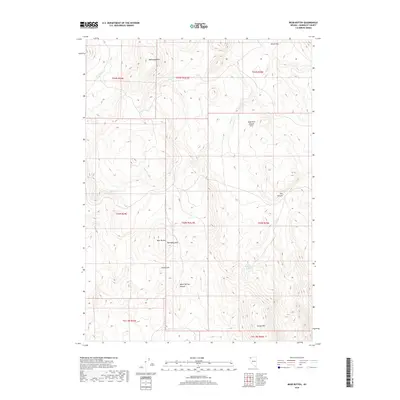
2018 Map of Bear Buttes
USGS Topo · Published 2018About this map
Chinatown sits in the high desert of Humboldt County, positioned near the dramatic formations of the Bear Buttes. This landscape is defined by its arid drainage patterns and isolated peaks, where water sources like Tenmile Spring and Rock Spring provide critical points of interest in an otherwise dry expanse. The terrain rises sharply to Mahogany Mtn and Trough Mtn, with deep cuts such as Warm Springs Canyon and Dry Canyon carving through the volcanic hills. The presence of Alkali Flat in the northeast indicates the seasonal collection of water in this basin-and-range environment. This 2018 survey detail provides a modern inventory of these remote landmarks, showing the proximity of the High Rock Canyon Hills and the ephemeral flow of Sand Cr through the interior valleys.
Find a feature on this map
21 named features on this map. Tap any name to fly to it.
Don’t see what you’re looking for? This feature index may not catch every label — zoom into the map to look around manually.
Map Details
Editions of this 2018 Bear Buttes Map
This is the sole edition of this map. No revisions or reprints were ever made.
Other maps of this area

1889 · Long Valley
USGS Topo · 1:250,000

1954 · Vya
USGS Topo · 1:250,000

1958 · Vya
USGS Topo · 1:250,000

1962 · Vya
USGS Topo · 1:250,000

1965 · Rock Spring Table
USGS Topo · 1:62,500

1966 · Blowout Mtn
USGS Topo · 1:24,000

1966 · Badger Mtn SE
USGS Topo · 1:24,000

1972 · Soldier Meadow
USGS Topo · 1:24,000
1972 · Red Mountain
USGS Topo · 1:24,000
1972 · Yellow Hills East
USGS Topo · 1:24,000