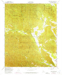
1949 Map of Bear Canyon
USGS Topo · Published 1975About this map
Hunter Liggett Military Reservation and the Los Padres National Forest dominate this landscape, illustrating the mid-century overlap of federal land management and military activity in Monterey County. The terrain is defined by the winding course of the San Antonio River and its various tributaries, including Pinalito Creek and Mission Creek. Tracing the valley floor, the Del Venturi Road provides a central corridor through the reservation, passing near named landforms like China Gulch. The map captures the area as it stood in the late 1940s, showing early infrastructure such as a prominent Telephone Line and remote roads like Coleman Canyon Road. Sections such as Milpitas and San Miguelito reflect the localized geographic divisions within the larger forest and military boundaries, while the presence of Wizard Gulch highlights the detailed topographic surveying of these interior canyons.
Find a feature on this map
19 named features on this map. Tap any name to fly to it.
Don’t see what you’re looking for? This feature index may not catch every label — zoom into the map to look around manually.
Map Details
Editions of this 1949 Bear Canyon Map
4 editions found
Other maps of this area

1919 · King City
USGS Topo · 1:62,500

1919 · Junipero Serra
USGS Topo · 1:62,500

1919 · Bryson
USGS Topo · 1:62,500

1921 · Cape San Martin
USGS Topo · 1:62,500

1939 · King City
USGS Topo · 1:62,500

1941 · Cape San Martin
USGS Topo · 1:62,500

1941 · Junipero Serra
USGS Topo · 1:62,500

1941 · Bryson
USGS Topo · 1:62,500

1942 · Bryson
USGS Topo · 1:62,500

1942 · Cape San Martin
USGS Topo · 1:62,500