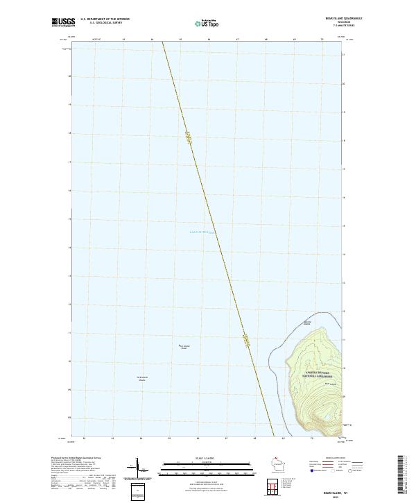
2022 Map of Bear Island
USGS Topo · Published 2022About this map
Bear Island dominates the southeastern quadrant of this maritime-focused survey, situated within the protected boundaries of the Apostle Islands National Lakeshore. The map documents a sparsely populated but ecologically significant portion of the Apostle Islands chain, emphasizing the land-water interface where the island's rising topography meets the vast expanse of Lake Superior. Submerged hazards for navigation are clearly delineated, including the expansive Bear Island Shoal to the west and the northern reaches of the York Island Shoals. A significant administrative boundary bisects the open waters, marking the line between Ashland and Bayfield Counties. This contemporary study captures the island's isolation and its status as a preserved natural landscape, devoid of modern road networks or urban development.
Find a feature on this map
9 named features on this map. Tap any name to fly to it.
Don’t see what you’re looking for? This feature index may not catch every label — zoom into the map to look around manually.
Map Details
Editions of this 2022 Bear Island Map
This is the sole edition of this map. No revisions or reprints were ever made.
Other maps of this area

1941 · Bayfield
USGS Topo · 1:48,000

1946 · Bayfield
USGS Topo · 1:48,000

1953 · Ashland
USGS Topo · 1:250,000

1954 · Two Harbors
USGS Topo · 1:250,000

1957 · Two Harbors
USGS Topo · 1:250,000

1958 · Ashland
USGS Topo · 1:250,000

1958 · Two Harbors
USGS Topo · 1:250,000

1963 · Rocky Island
USGS Topo · 1:62,500

1963 · Oak Island
USGS Topo · 1:24,000
1963 · Bear Island
USGS Topo · 1:24,000