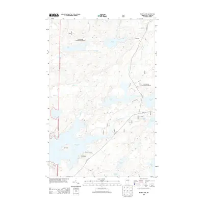
2013 Map of Bear Island
USGS Topo · Published 2013About this map
Rothman sits at the southern edge of a landscape defined by its intricate network of lakes and waterways in northeastern Minnesota. This 2013 survey captures the area as it is primarily managed within the Superior National Forest, where the terrain is dominated by significant water bodies such as Bear Island Lake, Birch Lake, and One Pine Lake. The central portion of the map is unified by the winding path of the Bear Island River and the Beaver River, which flow through a dense forest setting. Local access is primarily maintained through routes like Hwy 21 N and Co Hwy 120, serving the small residential clusters and seasonal cabins near Bear Island. The survey documents a late-twentieth-century preservation of this wilderness corridor, showing how geographic features like Mitchell Lake and Johnson Lake remain central to the identity of this St. Louis County region.
Find a feature on this map
31 named features on this map. Tap any name to fly to it.
Don’t see what you’re looking for? This feature index may not catch every label — zoom into the map to look around manually.
Map Details
Editions of this 2013 Bear Island Map
This is the sole edition of this map. No revisions or reprints were ever made.
Other maps of this area

1933 · Ely
USGS Topo · 1:62,500

1939 · Ely
USGS Topo · 1:62,500

1949 · Isaac Lake
USGS Topo · 1:24,000

1950 · Isaac Lake
USGS Topo · 1:24,000

1951 · Babbitt
USGS Topo · 1:24,000

1952 · Babbitt NE
USGS Topo · 1:24,000

1954 · Two Harbors
USGS Topo · 1:250,000

1954 · Hibbing
USGS Topo · 1:250,000

1956 · Crab Lake
USGS Topo · 1:24,000

1956 · Eagles Nest
USGS Topo · 1:24,000
Featured Places
- Rothman, MN
- Birch Lake (Unorganized Territory), MN
- Morse Township, MN
- Saint Louis County, MN
- United States