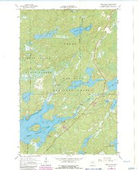
1965 Map of Bear Island
USGS Topo · Published 1986About this map
Superior National Forest and Beaver State Forest dominate this stretch of the Minnesota Northwoods, where a labyrinth of glacial lakes and connected waterways defines the terrain. The sprawling Bear Island Lake sits at the heart of the area, featuring the prominent Bear Island and a complex shoreline of points and bays, including Log Bay. The map provides specific depth curves and soundings for these waters, which were compiled from Minnesota Department of Conservation charts. Settlement is sparse in this heavily forested region, with the small locale of Rothman appearing near the southwest corner. The landscape is characterized by a high density of water bodies, from the larger Birch Lake and Mitchell Lake to smaller basins like Canary Lake and Whisper Lake, all linked by drainages such as Johnson Creek and Longstorff Creek.
Find a feature on this map
24 named features on this map. Tap any name to fly to it.
Don’t see what you’re looking for? This feature index may not catch every label — zoom into the map to look around manually.
Map Details
Editions of this 1965 Bear Island Map
3 editions found
Other maps of this area

1933 · Ely
USGS Topo · 1:62,500

1939 · Ely
USGS Topo · 1:62,500

1949 · Isaac Lake
USGS Topo · 1:24,000

1950 · Isaac Lake
USGS Topo · 1:24,000

1951 · Babbitt
USGS Topo · 1:24,000

1952 · Babbitt NE
USGS Topo · 1:24,000

1954 · Two Harbors
USGS Topo · 1:250,000

1954 · Hibbing
USGS Topo · 1:250,000

1956 · Crab Lake
USGS Topo · 1:24,000

1956 · Eagles Nest
USGS Topo · 1:24,000
Featured Places
- Rothman, MN
- Morse Township, MN
- Birch Lake (Unorganized Territory), MN
- Saint Louis County, MN
- United States