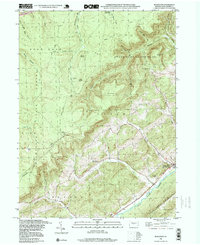
1998 Map of Bear Knob
USGS Topo · Published 1999About this map
The sharp ridge of Bald Eagle Mountain and the winding course of Eagle Creek dominate the southeastern landscape of this Centre County quadrangle. Near the foot of the mountain, the community of Unionville sits as a primary settlement, complemented by local landmarks like Oak Ridge Cem and Julian Cem. The terrain rises sharply to the north and west into the dense woodlands of Moshannon State Forest and State Game Lands No 103, where the topography is defined by high points like Bear Knob and Ganderstep Knob. Small rural institutions, such as Dicks Run Ch, are scattered along the narrow valley floors. Transportation history is visible in the transition from the Old RR Grade to established routes like the Julian Pike and Snow Shoe Road, while an Airway Beacon and several Radio Towers on the ridges signify the era's navigational infrastructure.
Find a feature on this map
43 named features on this map. Tap any name to fly to it.
Don’t see what you’re looking for? This feature index may not catch every label — zoom into the map to look around manually.
Map Details
Editions of this 1998 Bear Knob Map
This is the sole edition of this map. No revisions or reprints were ever made.
Other maps of this area

1908 · Bellefonte
USGS Topo · 1:62,500

1909 · Bellefonte
USGS Topo · 1:62,500

1922 · Philipsburg
USGS Topo · 1:62,500

1928 · Snow Shoe
USGS Topo · 1:48,000

1929 · Karthaus
USGS Topo · 1:62,500

1931 · Show Shoe
USGS Topo · 1:62,500

1932 · Karthaus
USGS Topo · 1:62,500

1939 · Philipsburg
USGS Topo · 1:62,500

1943 · Lewistown
USGS Topo · 1:125,000

1945 · Philipsburg
USGS Topo · 1:62,500