
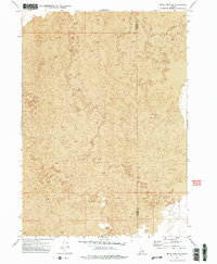
1972 Map of Bear Park SW
USGS Topo · Published 1976About this map
Lava fields dominate this 1970s topographic study of the High Desert region in southern Idaho. The landscape is characterized by intricate volcanic formations, with the survey capturing the complex texture of the Lava flows that define the terrain. The boundary between Minidoka Co and Blaine Co runs vertically through the eastern portion of the map, marking a political division across a geological expanse largely void of permanent human settlement or infrastructure. This map is a stark record of the Snake River Plain's volcanic heritage, showing the raw topographic contours of the earth before any modern developments or modifications. It serves as a specific reference for geologists and desert researchers interested in the undisturbed state of these volcanic features during the early 1970s.
Find a feature on this map
2 named features on this map. Tap any name to fly to it.
Don’t see what you’re looking for? This feature index may not catch every label — zoom into the map to look around manually.
Map Details
Editions of this 1972 Bear Park SW Map
2 editions found
Other maps of this area

1954 · Pocatello
USGS Topo · 1:250,000

1955 · Idaho Falls
USGS Topo · 1:250,000

1958 · Idaho Falls
USGS Topo · 1:250,000

1958 · Pocatello
USGS Topo · 1:250,000

1972 · Bear Trap Cave
USGS Topo · 1:24,000

1972 · Mule Butte
USGS Topo · 1:24,000

1972 · Bear Den Butte
USGS Topo · 1:24,000

1972 · Bear Park East
USGS Topo · 1:24,000

1972 · Bottleneck Lake
USGS Topo · 1:24,000

1972 · Bear Park West
USGS Topo · 1:24,000