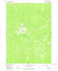
1982 Map of Bear Peak
USGS Topo · Published 1982About this map
Klamath National Forest dominates this high-elevation landscape, where the Kelsey Range creates a sharp divide between multiple watershed systems. The terrain is defined by a series of steep drainages, including Clear Creek and its southern fork, which cut through the northern and eastern portions of the quadrangle. High alpine water features are clustered near the center of the map around the 5,740-foot Bear Peak, where Little Bear Lake, Lower Bear Lake, and Bear Lake sit in glacial cirques below the ridges. A lone Campground along Clear Creek and the presence of names like Slippery and Elbow Spring indicate the early recreational and logging access into this part of Siskiyou County. To the south, the Dillon Divide separates the North Fork Dillon Creek from the surrounding northern basins, illustrating the complex topography that constrained movement and land use in this wilderness area during the late twentieth century.
Find a feature on this map
29 named features on this map. Tap any name to fly to it.
Don’t see what you’re looking for? This feature index may not catch every label — zoom into the map to look around manually.
Map Details
Editions of this 1982 Bear Peak Map
2 editions found
Other maps of this area

1914 · Seiad
USGS Topo · 1:125,000

1922 · Preston Peak
USGS Topo · 1:125,000

1922 · Seiad
USGS Topo · 1:125,000

1948 · Weed
USGS Topo · 1:250,000

1950 · Weed
USGS Topo · 1:250,000

1955 · Dillon Mtn
USGS Topo · 1:62,500

1955 · Ukonom Lake
USGS Topo · 1:62,500

1956 · Happy Camp
USGS Topo · 1:62,500

1956 · Preston Peak
USGS Topo · 1:62,500

1958 · Weed
USGS Topo · 1:250,000