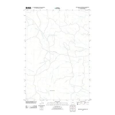
2011 Map of Bear Skull Mountain
USGS Topo · Published 2011About this map
Bear Skull Mountain anchors this high-plains landscape in southeastern Montana, where a complex network of seasonal drainages has carved the terrain of Powder River County. The area is defined by the headwaters of numerous creeks, most notably the Baking Powder Creek system and its North Fork and South Fork tributaries. Human presence is sparse, represented primarily by Baking Powder Rd, which provides the primary access through this rangeland.
Find a feature on this map
15 named features on this map. Tap any name to fly to it.
Don’t see what you’re looking for? This feature index may not catch every label — zoom into the map to look around manually.
Map Details
Editions of this 2011 Bear Skull Mountain Map
This is the sole edition of this map. No revisions or reprints were ever made.
Other maps of this area

1954 · Ekalaka
USGS Topo · 1:250,000

1956 · Ekalaka
USGS Topo · 1:250,000

1958 · Ekalaka
USGS Topo · 1:250,000

1965 · Ekalaka
USGS Topo · 1:250,000

1970 · Pine Creek
USGS Topo · 1:24,000

1970 · Wild Bill Creek
USGS Topo · 1:24,000

1970 · Baldy Peak
USGS Topo · 1:24,000
1970 · Biddle
USGS Topo · 1:24,000
1970 · Bay Horse
USGS Topo · 1:24,000

1970 · Bear Skull Mountain
USGS Topo · 1:24,000