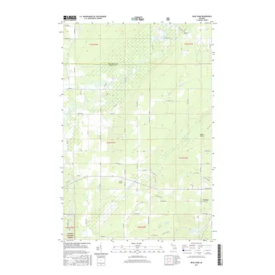
2017 Map of Bear Town
USGS Topo · Published 2017About this map
Sturgeon River and its meandering tributaries dominate this northern Michigan landscape on the edge of Keweenaw Bay. The geography reveals a transition from the managed timberlands of the Ottawa National Forest in the south toward the settled areas near Baraga. These lowlands are defined by a complex network of waterways, including Little Carp River, Gristmill Cr, and Kelsey Cr, which reflect the region’s hydraulic character.
Find a feature on this map
45 named features on this map. Tap any name to fly to it.
Don’t see what you’re looking for? This feature index may not catch every label — zoom into the map to look around manually.
Map Details
Editions of this 2017 Bear Town Map
This is the sole edition of this map. No revisions or reprints were ever made.
Other maps of this area

1954 · Keweenaw Bay
USGS Topo · 1:62,500

1954 · Pelkie
USGS Topo · 1:62,500

1954 · Sidnaw
USGS Topo · 1:62,500

1955 · Herman
USGS Topo · 1:62,500

1958 · Iron River
USGS Topo · 1:250,000

1960 · Iron River
USGS Topo · 1:250,000

1961 · Iron River
USGS Topo · 1:250,000

1967 · Iron River
USGS Topo · 1:250,000
1984 · Pine Lake
USGS Topo · 1:24,000
1984 · Portage Entry
USGS Topo · 1:24,000