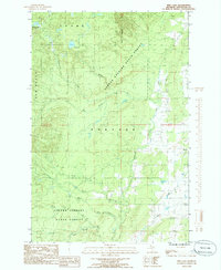
1984 Map of Pine Lake
USGS Topo · Published 1985About this map
Copper Country State Forest dominates this mid-1980s landscape in Houghton County, where the dense timberlands are carved by a complex network of waterways. The settlement of Tapiola sits on the eastern edge of the quadrangle, serving as a focal point for local history along with a nearby Cem. The hydrology of the region is exceptionally detailed, featuring the Elm River and the Otter River, which are fed by numerous named tributaries like Sante River and Ebers Creek.
Find a feature on this map
18 named features on this map. Tap any name to fly to it.
Don’t see what you’re looking for? This feature index may not catch every label — zoom into the map to look around manually.
Map Details
Editions of this 1984 Pine Lake Map
This is the sole edition of this map. No revisions or reprints were ever made.
Other maps of this area

1915 · Houghton
USGS Topo · 1:62,500

1946 · Chassell
USGS Topo · 1:24,000

1946 · South Range
USGS Topo · 1:24,000

1948 · South Range
USGS Topo · 1:24,000

1948 · Chassell
USGS Topo · 1:24,000

1954 · Graveraet River
USGS Topo · 1:24,000

1954 · Pelkie
USGS Topo · 1:62,500

1954 · Winona
USGS Topo · 1:62,500

1954 · Houghton
USGS Topo · 1:62,500

1958 · Hancock
USGS Topo · 1:250,000