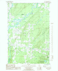
1985 Map of Bear Town
USGS Topo · Published 1985About this map
The Sturgeon River and Otter River wind through the heavily forested interior of the Upper Peninsula, defining a landscape at the intersection of several major land management boundaries. This mid-1980s record documents the sprawling L'Anse Indian Reservation and the Ottawa National Forest, where the terrain is marked by industrial and historical transit corridors. Remnants of the region's logging and transport history are visible in the Old RR Grade and the Trading Strip near Gristmill Creek. The transition from the rural interior toward the Keweenaw Bay is anchored by the settlement of Baraga, positioned near the Baraga State Park. Further inland, the smaller community of Bear Town sits within the reservation boundaries, while the Copper Country State Forest occupies the southeastern corner near Bendry Lake.
Find a feature on this map
23 named features on this map. Tap any name to fly to it.
Don’t see what you’re looking for? This feature index may not catch every label — zoom into the map to look around manually.
Map Details
Editions of this 1985 Bear Town Map
This is the sole edition of this map. No revisions or reprints were ever made.
Other maps of this area

1954 · Keweenaw Bay
USGS Topo · 1:62,500

1954 · Pelkie
USGS Topo · 1:62,500

1954 · Sidnaw
USGS Topo · 1:62,500

1955 · Herman
USGS Topo · 1:62,500

1958 · Iron River
USGS Topo · 1:250,000

1960 · Iron River
USGS Topo · 1:250,000

1961 · Iron River
USGS Topo · 1:250,000

1967 · Iron River
USGS Topo · 1:250,000
1984 · Pine Lake
USGS Topo · 1:24,000
1984 · Portage Entry
USGS Topo · 1:24,000