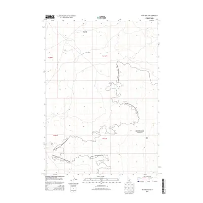
2013 Map of Bear Trap Cave
USGS Topo · Published 2013About this map
Craters of the Moon National Preserve dominates this southern Idaho landscape, revealing the complex volcanic geology of Blaine County. This modern survey illustrates a high-desert environment defined by basaltic formations and subterranean features, most notably the namesake Bear Trap Cave and the nearby Bear Trap Lava Tube. These geologic structures, along with the expansive Wapi Flow to the southeast, represent the unique volcanic activity that has shaped the Snake River Plain. Human interaction with this isolated terrain is sparse but evident, marked by the presence of Lulu Reservoir and the Bear Trap Airport landing strip. Local access is primarily maintained via the unpaved corridor of Bear Trap Rd, which cuts through the sagebrush and lava fields, providing a point of entry for researchers and explorers of the basaltic Split Butte and the surrounding wilderness.
Find a feature on this map
12 named features on this map. Tap any name to fly to it.
Don’t see what you’re looking for? This feature index may not catch every label — zoom into the map to look around manually.
Map Details
Editions of this 2013 Bear Trap Cave Map
This is the sole edition of this map. No revisions or reprints were ever made.
Other maps of this area

1954 · Pocatello
USGS Topo · 1:250,000

1955 · Idaho Falls
USGS Topo · 1:250,000

1958 · Idaho Falls
USGS Topo · 1:250,000

1958 · Pocatello
USGS Topo · 1:250,000

1972 · Schodde Well
USGS Topo · 1:24,000
1972 · Rattlesnake Butte
USGS Topo · 1:24,000

1972 · Bear Trap Cave
USGS Topo · 1:24,000

1972 · Mule Butte
USGS Topo · 1:24,000

1972 · Bear Park SW
USGS Topo · 1:24,000

1972 · Minidoka
USGS Topo · 1:24,000