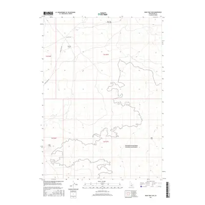
2017 Map of Bear Trap Cave
USGS Topo · Published 2017About this map
The volcanic geology of Idaho's Snake River Plain dominates this modern survey, defined by the extensive Wapi Flow and the northern reaches of the Craters of the Moon National Monument. The landscape is a study in subterranean and surface lava features, prominently featuring the Bear Trap Cave and the Bear Trap Lava Tube in the northern sections. Human presence is sparse and utilitarian in this arid environment, represented by the remote Bear Trap Airport and the lonely course of the Minidoka to Arco Rd. While the terrain appears desolate, the inclusion of Lulu Reservoir and markers like Split Butte indicate the careful mapping of vital landmarks and water resources necessary for navigating this complex volcanic field.
Find a feature on this map
12 named features on this map. Tap any name to fly to it.
Don’t see what you’re looking for? This feature index may not catch every label — zoom into the map to look around manually.
Map Details
Editions of this 2017 Bear Trap Cave Map
This is the sole edition of this map. No revisions or reprints were ever made.
Other maps of this area

1954 · Pocatello
USGS Topo · 1:250,000

1955 · Idaho Falls
USGS Topo · 1:250,000

1958 · Idaho Falls
USGS Topo · 1:250,000

1958 · Pocatello
USGS Topo · 1:250,000

1972 · Schodde Well
USGS Topo · 1:24,000
1972 · Rattlesnake Butte
USGS Topo · 1:24,000

1972 · Bear Trap Cave
USGS Topo · 1:24,000

1972 · Mule Butte
USGS Topo · 1:24,000

1972 · Bear Park SW
USGS Topo · 1:24,000

1972 · Minidoka
USGS Topo · 1:24,000