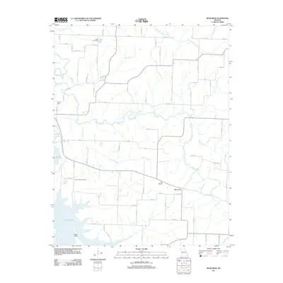
2011 Map of Bearcreek
USGS Topo · Published 2011About this map
Bearcreek serves as a central point in this rural landscape, situated south of the branching waters of Bear Creek. The geography is defined by its drainages, where Crabtree Branch and Price Branch feed into the larger water systems that include the significant expanse of Stockton Lake to the southwest. This 2011 survey captures the area's agricultural and social foundations, featuring landmarks like the Friendship Community Hall and the notable elevation of The Mound. Evidence of early industry and water management remains visible through labels for Owens Mill on Bear Creek and the Truitt Lake Dam to the north. The terrain transitions from the low-lying river valleys of the Sac River to the higher ground of Indian Ridge, connected by a network of rural roads such as Cemetery RD and Road 1750 that link the scattered homesteads and local landmarks.
Find a feature on this map
39 named features on this map. Tap any name to fly to it.
Don’t see what you’re looking for? This feature index may not catch every label — zoom into the map to look around manually.
Map Details
Editions of this 2011 Bearcreek Map
This is the sole edition of this map. No revisions or reprints were ever made.
Other maps of this area

1886 · Stockton
USGS Topo · 1:125,000

1939 · Caplinger Mills
USGS Topo · 1:24,000

1939 · Arnica
USGS Topo · 1:24,000

1941 · Caplinger Mills
USGS Topo · 1:24,000

1941 · Arnica
USGS Topo · 1:24,000

1944 · Humansville
USGS Topo · 1:24,000

1954 · Springfield
USGS Topo · 1:250,000
1956 · Fair Play
USGS Topo · 1:24,000
1956 · Stockton
USGS Topo · 1:24,000
1956 · Bearcreek
USGS Topo · 1:24,000