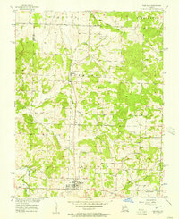
1956 Map of Fair Play
USGS Topo · Published 1957About this map
Fair Play serves as a central hub for the surrounding township of Madison, where the agricultural landscape is shaped by the numerous waterways feeding the Missouri River Basin. The settlement of Dunnegan sits to the north near Dunnegan Spring, anchoring a region defined by family cemeteries and rural congregations such as Plum Grove Ch and Bismount Ch. Local history is visible in the network of country roads connecting landmarks like Bushy Creek Cem and Pickel Cem. The presence of an abandoned Woodlawn Sch near Barren Creek Ch and a Landing Field near the main town site reflects the mid-century shift in local infrastructure, while the border of Cedar and Polk Counties runs through the western terrain, following the drainages of Case Spring and Moore Creek.
Find a feature on this map
30 named features on this map. Tap any name to fly to it.
Don’t see what you’re looking for? This feature index may not catch every label — zoom into the map to look around manually.
Map Details
Editions of this 1956 Fair Play Map
2 editions found
Other maps of this area

1884 · Bolivar
USGS Topo · 1:125,000

1886 · Stockton
USGS Topo · 1:125,000

1892 · Bolivar
USGS Topo · 1:125,000

1939 · Arnica
USGS Topo · 1:24,000

1941 · Arnica
USGS Topo · 1:24,000

1942 · Elkton
USGS Topo · 1:24,000

1944 · Humansville
USGS Topo · 1:24,000

1949 · Elkton
USGS Topo · 1:24,000

1950 · Elkton
USGS Topo · 1:24,000

1950 · Cliquot
USGS Topo · 1:24,000