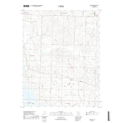
2017 Map of Bearcreek
USGS Topo · Published 2017About this map
The settlement of Bearcreek serves as a central point in this Cedar County landscape, situated near the intersection of several local routes like 1620 Rd Cedar. The area is defined by a dense network of watercourses, including the Sac River and the extensive southern reach of Stockton Lake, which creates a complex shoreline near Indian Ridge. Notable local landmarks such as The Mound and the Lindley Prairie Cem provide specific points of interest for those tracing local family history or geographic changes. The terrain is marked by numerous small tributaries, including Crabtree Br, Price Br, and Alder Br, which drain the undulating countryside. To the north, Montgomery Lake and Truitt Lake offer further evidence of the region's managed water resources during this period of the twenty-first century.
Find a feature on this map
60 named features on this map. Tap any name to fly to it.
Don’t see what you’re looking for? This feature index may not catch every label — zoom into the map to look around manually.
Map Details
Editions of this 2017 Bearcreek Map
This is the sole edition of this map. No revisions or reprints were ever made.
Other maps of this area

1886 · Stockton
USGS Topo · 1:125,000

1939 · Caplinger Mills
USGS Topo · 1:24,000

1939 · Arnica
USGS Topo · 1:24,000

1941 · Caplinger Mills
USGS Topo · 1:24,000

1941 · Arnica
USGS Topo · 1:24,000

1944 · Humansville
USGS Topo · 1:24,000

1954 · Springfield
USGS Topo · 1:250,000
1956 · Fair Play
USGS Topo · 1:24,000
1956 · Stockton
USGS Topo · 1:24,000
1956 · Bearcreek
USGS Topo · 1:24,000