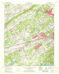
1966 Map of Bearden
USGS Topo · Published 1968About this map
Beaver Valley and the surrounding ridges of west Knoxville are shown here during a period of rapid suburbanization. The map documents the expansion of neighborhoods like West Hills, Rocky Hill, and Cumberland Estates into previously agricultural land between Blackoak Ridge and Beaver Ridge. This development follows the corridors of Kingston Pike and the newly established interstate routes.
Find a feature on this map
147 named features on this map. Tap any name to fly to it.
Don’t see what you’re looking for? This feature index may not catch every label — zoom into the map to look around manually.
Map Details
Editions of this 1966 Bearden Map
This is the sole edition of this map. No revisions or reprints were ever made.
Other maps of this area

1886 · Knoxville
USGS Topo · 1:125,000

1892 · Knoxville
USGS Topo · 1:125,000

1893 · Briceville
USGS Topo · 1:125,000

1894 · Knoxville
USGS Topo · 1:125,000

1895 · Loudon
USGS Topo · 1:125,000

1895 · Briceville
USGS Topo · 1:125,000

1895 · Knoxville
USGS Topo · 1:125,000

1896 · Briceville
USGS Topo · 1:125,000

1897 · Maynardville
USGS Topo · 1:125,000

1900 · Maynardville
USGS Topo · 1:125,000