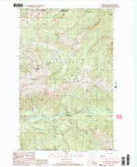
1989 Map of Bearpaw Mountain
USGS Topo · Published 1989About this map
The North Fork Nooksack River carves a deep path through this section of Whatcom County, creating a landscape defined by dramatic elevation changes and essential water resources. Near the southern edge of the map, industrial and utility footprints appear at the Nooksack Power Plant and a Gage Station, positioned downstream from the landmark Nooksack Falls. This area serves as a primary drainage basin for the surrounding heights, with numerous named tributaries such as Wells Creek, Deadhorse Creek, and Fossil Creek feeding into the main river channel.
Find a feature on this map
37 named features on this map. Tap any name to fly to it.
Don’t see what you’re looking for? This feature index may not catch every label — zoom into the map to look around manually.
Map Details
Editions of this 1989 Bearpaw Mountain Map
2 editions found
Other maps of this area

1909 · Mt Baker
USGS Topo · 1:192,000

1915 · Mt. Baker
USGS Topo · 1:250,000

1952 · Mt. Baker
USGS Topo · 1:62,500

1953 · Mt Shuksan
USGS Topo · 1:62,500

1955 · Concrete
USGS Topo · 1:250,000

1958 · Concrete
USGS Topo · 1:250,000

1962 · Concrete
USGS Topo · 1:250,000

1979 · Mt. Baker
USGS Topo · 1:100,000
1989 · Shuksan Arm
USGS Topo · 1:24,000
1989 · Groat Mountain
USGS Topo · 1:24,000