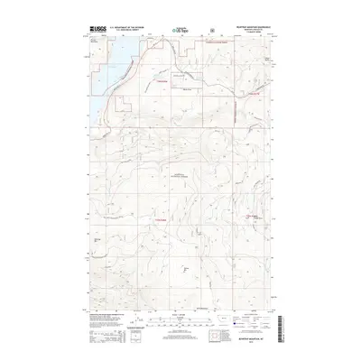
2014 Map of Beartrap Mountain
USGS Topo · Published 2014About this map
Kootenai National Forest dominates this section of Lincoln County, where the topography transitions from the Salish Mountains in the south to the Purcell Mountains in the northwest. A primary geographical feature is Lake Koocanusa, a reservoir formed by the damming of the Kootenai River, which is flanked by Mount Hwy 37. The map illustrates a landscape shaped by water and elevation, including the notable Pinkham Falls and various drainages such as Melvin Draw and Trough Draw. This area is characterized by its network of forest development roads, such as Pinkham Rd and Phills Lake Rd, which provide access to interior landmarks like Beartrap Mtn and Helmer Mtn. For those interested in land management and mountain geography, the map provides precise detail on the intersection of various creeks, including Pinkham Cr and Sutton Cr, as they navigate the high-altitude terrain.
Find a feature on this map
42 named features on this map. Tap any name to fly to it.
Don’t see what you’re looking for? This feature index may not catch every label — zoom into the map to look around manually.
Map Details
Editions of this 2014 Beartrap Mountain Map
This is the sole edition of this map. No revisions or reprints were ever made.
Other maps of this area

1957 · Kalispell
USGS Topo · 1:250,000

1960 · Kalispell
USGS Topo · 1:250,000

1961 · Kalispell
USGS Topo · 1:250,000

1963 · Rexford
USGS Topo · 1:24,000

1963 · Eureka North
USGS Topo · 1:24,000

1963 · Mc Guire Mountain
USGS Topo · 1:24,000

1963 · Eureka South
USGS Topo · 1:24,000

1963 · Red Mountain
USGS Topo · 1:24,000

1963 · Webb Mountain
USGS Topo · 1:24,000
1963 · Pinkham Mountain
USGS Topo · 1:24,000