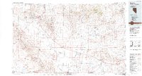
1986 Map of Beatty
USGS Topo · Published 1986About this map
The Amargosa Desert and the high desert of Southern Nevada come into sharp focus in this mid-1980s compilation. The town of Beatty serves as a central hub, surrounded by a legacy of gold and mineral extraction evident in labels for the Gold Bar mine, the Original Bullfrog Mine, and the Senator Stewart Mine. To the east, the landscape is partitioned by the massive federal holdings of the Nellis Air Force Range and the Nevada Test Site, where infrastructure like the Desert Rock Airstrip and the settlement of Mercury support specialized operations. Toward the southwest, the terrain descends into the stark geography of Death Valley National Monument, crossing the border into California at the Grapevine Mountains and the Funeral Mountains. The map reveals the relationship between early 20th-century mining ghosts like Rhyolite and Bullfrog and the modern military-industrial complex that reshaped the Great Basin.
Find a feature on this map
81 named features on this map. Tap any name to fly to it.
Don’t see what you’re looking for? This feature index may not catch every label — zoom into the map to look around manually.
Map Details
Editions of this 1986 Beatty Map
2 editions found
Other maps of this area

1907 · Las Vegas
USGS Topo · 1:250,000

1908 · Kawich
USGS Topo · 1:250,000

1908 · Lida
USGS Topo · 1:250,000

1908 · Furnace Creek
USGS Topo · 1:250,000

1908 · Las Vegas
USGS Topo · 1:250,000

1908 · Ballarat
USGS Topo · 1:250,000

1910 · Furnace Creek
USGS Topo · 1:250,000

1913 · Lida
USGS Topo · 1:250,000

1913 · Ballarat
USGS Topo · 1:250,000
1942 · Emigrant Valley
USGS Topo · 1:125,000