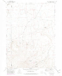
1971 Map of Beatys Butte
USGS Topo · Published 1980About this map
Beatys Butte dominates this high desert landscape along the border of Lake and Harney counties, representing a remote corner of southeastern Oregon as it appeared in the early 1970s. The terrain is defined by its water sources and volcanic topography, with numerous reliable points such as Willow Spring, North Spring, and Mustang Spring serving as vital landmarks in an otherwise arid environment.
Find a feature on this map
22 named features on this map. Tap any name to fly to it.
Don’t see what you’re looking for? This feature index may not catch every label — zoom into the map to look around manually.
Map Details
Editions of this 1971 Beatys Butte Map
2 editions found
Other maps of this area

1955 · Adel
USGS Topo · 1:250,000

1957 · Adel
USGS Topo · 1:250,000

1958 · Adel
USGS Topo · 1:250,000

1962 · Adel
USGS Topo · 1:250,000

1971 · Fish Fin Rim
USGS Topo · 1:24,000

1971 · Beatys Butte
USGS Topo · 1:24,000

1971 · Surveyors Lake
USGS Topo · 1:24,000

1971 · Mahogany Butte
USGS Topo · 1:24,000

1971 · Murphy Waterholes
USGS Topo · 1:24,000
1971 · Guano Reservoir
USGS Topo · 1:24,000