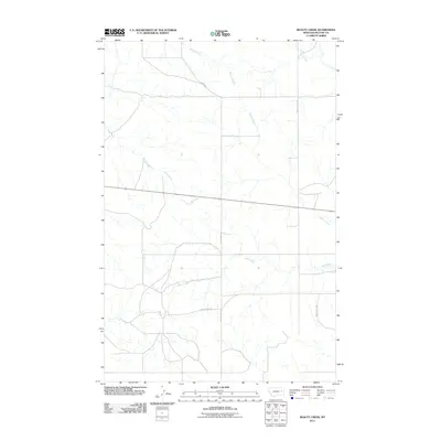
2011 Map of Beauty Creek
USGS Topo · Published 2011About this map
Beauty Creek winds through this expanse of McCone County, Montana, providing a central drainage for a series of tributary systems. The landscape is defined by the carved paths of Soda Creek and Dirty Creek, which cut across the prairie terrain. The road network reflects the vast scale of the high plains, where long stretches like Chalk Butte Rd and Logan Rd provide the primary infrastructure for traversing the rangeland. In the northern reaches, Nelson Creek and Cotter Creek add further complexity to the hydrological profile of the region. This 2011 survey illustrates the sparse but vital connectivity of rural Montana, where transportation follows the natural contours of the valley systems, such as the area surrounding Beauty Valley Rd.
Find a feature on this map
9 named features on this map. Tap any name to fly to it.
Don’t see what you’re looking for? This feature index may not catch every label — zoom into the map to look around manually.
Map Details
Editions of this 2011 Beauty Creek Map
This is the sole edition of this map. No revisions or reprints were ever made.
Other maps of this area

1954 · Jordan
USGS Topo · 1:250,000

1954 · Glendive
USGS Topo · 1:250,000

1956 · Jordan
USGS Topo · 1:250,000

1957 · Glendive
USGS Topo · 1:250,000

1958 · Jordan
USGS Topo · 1:250,000

1958 · Glendive
USGS Topo · 1:250,000

1964 · Jordan
USGS Topo · 1:250,000

1965 · Hedstrom Lake
USGS Topo · 1:24,000

1965 · Watkins
USGS Topo · 1:24,000
1965 · Berry School
USGS Topo · 1:24,000