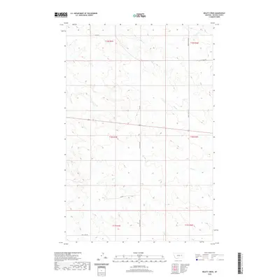
2020 Map of Beauty Creek
USGS Topo · Published 2020About this map
Nelson Cr and Beauty Creek define the drainage patterns of this rural McCone County landscape, where the high plains of eastern Montana are etched by seasonal waterways and isolated ranch roads. The network of corridors, including Logan Rd and Beauty Valley Rd, suggests a settlement pattern tied to the expansive grazing lands of the Big Dry country. The presence of Old Brockway Rd provides a link to older travel routes that once connected these remote townships. While much of the terrain is characterized by the draws of Soda Creek and Dirty Creek, the precision of the U.S. Geological Survey topographic lines reveals the subtle elevation changes of the broken land between Chalk Butte Rd and the northern reaches of Skull Creek Rd.
Find a feature on this map
17 named features on this map. Tap any name to fly to it.
Don’t see what you’re looking for? This feature index may not catch every label — zoom into the map to look around manually.
Map Details
Editions of this 2020 Beauty Creek Map
This is the sole edition of this map. No revisions or reprints were ever made.
Other maps of this area

1954 · Jordan
USGS Topo · 1:250,000

1954 · Glendive
USGS Topo · 1:250,000

1956 · Jordan
USGS Topo · 1:250,000

1957 · Glendive
USGS Topo · 1:250,000

1958 · Jordan
USGS Topo · 1:250,000

1958 · Glendive
USGS Topo · 1:250,000

1964 · Jordan
USGS Topo · 1:250,000

1965 · Hedstrom Lake
USGS Topo · 1:24,000

1965 · Watkins
USGS Topo · 1:24,000
1965 · Berry School
USGS Topo · 1:24,000