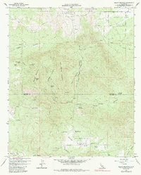
1960 Map of Beauty Mountain
USGS Topo · Published 1987About this map
The Cahuilla Indian Reservation occupies the northern border of this high-elevation terrain, where the landscape transitions into the cattle and ranching lands of the Durasno Valley and Terwilliger Valley. High points like Beauty Peak and Iron Mountain dominate the central topography, surrounded by a complex network of canyons including Rogers Canyon and Talmadge Canyon. Water is a critical resource in this arid environment, evidenced by named seeps and pools such as Iron Spring, Million Dollar Spring, and the Cooper Cienega.
Find a feature on this map
50 named features on this map. Tap any name to fly to it.
Don’t see what you’re looking for? This feature index may not catch every label — zoom into the map to look around manually.
Map Details
Editions of this 1960 Beauty Mountain Map
4 editions found
Other maps of this area

1901 · Southern California Sheet No. 1
USGS Topo · 1:250,000

1901 · San Jacinto
USGS Topo · 1:125,000

1903 · Ramona
USGS Topo · 1:125,000

1904 · Southern California Sheet No. 2
USGS Topo · 1:250,000

1904 · Southern California Sheet No. 1
USGS Topo · 1:250,000

1939 · Warner Springs
USGS Topo · 1:62,500

1939 · Palomar Mountain
USGS Topo · 1:62,500

1940 · Hemet Reservoir
USGS Topo · 1:62,500

1942 · Hemet Reservoir
USGS Topo · 1:62,500

1942 · Hemet
USGS Topo · 1:62,500