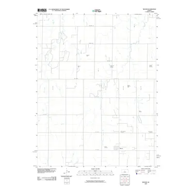
2009 Map of Beaver
USGS Topo · Published 2009About this map
Beaver serves as the central hub of this Kansas landscape, surrounded by an extensive network of petroleum extraction sites that define the local economy and land use. The map reveals a dense concentration of energy production, including the Meier Oil Field, Lang Oil Field, and the Hall-Gurney Oil and Gas Field. This industrial footprint is overlaid upon a traditional section-line road grid, with waterways such as Goose Creek and Beaver Creek meandering through the prairie. For those researching local heritage, the map identifies significant communal sites including Saint Josephs Cemetery, Presbyterian Cemetery, and Friends Cemetery, which provide clues to the denominational history of the early settlers. The eastern edge of the quadrangle includes the Dubuque Oil and Gas Field, further emphasizing the region's reliance on natural resources and the systematic development of the Barton County countryside.
Find a feature on this map
31 named features on this map. Tap any name to fly to it.
Don’t see what you’re looking for? This feature index may not catch every label — zoom into the map to look around manually.
Map Details
Editions of this 2009 Beaver Map
This is the sole edition of this map. No revisions or reprints were ever made.
Other maps of this area

1896 · Russell
USGS Topo · 1:125,000

1955 · Great Bend
USGS Topo · 1:250,000

1956 · Dorrance
USGS Topo · 1:24,000

1956 · Dorrance SW
USGS Topo · 1:24,000

1957 · Great Bend
USGS Topo · 1:250,000

1958 · Great Bend
USGS Topo · 1:250,000

1961 · Homer
USGS Topo · 1:24,000
1969 · Claflin
USGS Topo · 1:24,000
1969 · Beaver
USGS Topo · 1:24,000
1969 · Redwing
USGS Topo · 1:24,000