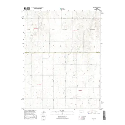
2015 Map of Beaver
USGS Topo · Published 2015About this map
The unincorporated community of Beaver sits at the intersection of the Barton and Russell county lines in the heart of Kansas wheat country. This landscape is defined by the gradual drainage of Beaver Cr and Goose Cr, where a strictly organized grid of rural roads like Michaelis Rd and Dubuque Ellsworth Rd facilitates agricultural transport. Several small cemeteries, including Saint Josephs Cem, Friends Cem, and Presbyterian Cem, are scattered across the townships, serving as primary touchstones for the area's genealogical history. The map illustrates the persistent 19th-century Public Land Survey System (PLSS) grid, which continues to dictate the placement of local thoroughfares and farmsteads well into the twenty-first century.
Find a feature on this map
22 named features on this map. Tap any name to fly to it.
Don’t see what you’re looking for? This feature index may not catch every label — zoom into the map to look around manually.
Map Details
Editions of this 2015 Beaver Map
This is the sole edition of this map. No revisions or reprints were ever made.
Other maps of this area

1896 · Russell
USGS Topo · 1:125,000

1955 · Great Bend
USGS Topo · 1:250,000

1956 · Dorrance
USGS Topo · 1:24,000

1956 · Dorrance SW
USGS Topo · 1:24,000

1957 · Great Bend
USGS Topo · 1:250,000

1958 · Great Bend
USGS Topo · 1:250,000

1961 · Homer
USGS Topo · 1:24,000
1969 · Claflin
USGS Topo · 1:24,000
1969 · Beaver
USGS Topo · 1:24,000
1969 · Redwing
USGS Topo · 1:24,000