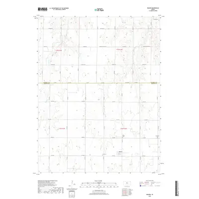
2018 Map of Beaver
USGS Topo · Published 2018About this map
Beaver serves as the primary community node in this portion of Barton County, where the plains are defined by the intersection of grid-based agricultural roads and subtle drainage systems. The settlement is situated at the junction of NE 190 Rd and NE 60 Ave, representing a classic Great Plains rural center. Local genealogy and historical social patterns are preserved through the locations of three distinct burial grounds: Saint Joseph's Cem, Friends Cem, and Presbyterian Cem, which are scattered among the section lines south of the Russell and Barton County line. The landscape is carved by seasonal watercourses including Goose Cr and Beaver Cr, which meander between the section roads, influencing the local topography and land use in a region primarily dedicated to expansive field cultivation.
Find a feature on this map
24 named features on this map. Tap any name to fly to it.
Don’t see what you’re looking for? This feature index may not catch every label — zoom into the map to look around manually.
Map Details
Editions of this 2018 Beaver Map
This is the sole edition of this map. No revisions or reprints were ever made.
Other maps of this area

1896 · Russell
USGS Topo · 1:125,000

1955 · Great Bend
USGS Topo · 1:250,000

1956 · Dorrance
USGS Topo · 1:24,000

1956 · Dorrance SW
USGS Topo · 1:24,000

1957 · Great Bend
USGS Topo · 1:250,000

1958 · Great Bend
USGS Topo · 1:250,000

1961 · Homer
USGS Topo · 1:24,000
1969 · Claflin
USGS Topo · 1:24,000
1969 · Beaver
USGS Topo · 1:24,000
1969 · Redwing
USGS Topo · 1:24,000