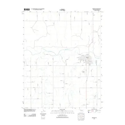
2012 Map of Beaver
USGS Topo · Published 2012About this map
The Oklahoma Panhandle town of Beaver serves as the focal point of this 2012 survey, situated along the northern banks of the Beaver River. The town's grid is clearly defined, with major thoroughfares like W Main St and Market St anchoring the settlement. To the south, the Beaver Municipal Airport and the Beaver Cem mark the transition from the residential center to the surrounding agricultural landscape.
Find a feature on this map
59 named features on this map. Tap any name to fly to it.
Don’t see what you’re looking for? This feature index may not catch every label — zoom into the map to look around manually.
Map Details
Editions of this 2012 Beaver Map
This is the sole edition of this map. No revisions or reprints were ever made.
Other maps of this area

1954 · Perryton
USGS Topo · 1:250,000

1958 · Perryton
USGS Topo · 1:250,000

1970 · Mocane NW
USGS Topo · 1:24,000

1971 · Clear Lake NW
USGS Topo · 1:24,000
1971 · Mocane SW
USGS Topo · 1:24,000

1973 · Balko
USGS Topo · 1:24,000

1973 · Balko NE
USGS Topo · 1:24,000

1973 · Floris
USGS Topo · 1:24,000
1973 · Forgan
USGS Topo · 1:24,000

1973 · Beaver
USGS Topo · 1:24,000