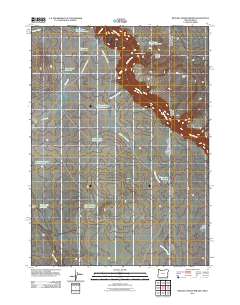
2011 Map of Beaver Charlie Breaks
USGS Topo · Published 2011About this map
The Owyhee River snakes through this high desert region of Malheur County, carving the distinct terrain of the Beaver Charlie Breaks. Human presence in this arid landscape is defined by water management and land use, evidenced by the Beaver Charlie Cabin and an extensive network of artificial catchments. These include the West Beaver Charlie Reservoir, Bull Creek Reservoir, and a series of reservoirs flanking the Oregon Hills, such as the North Oregon Hill Reservoir and Northwest Oregon Hill Reservoir. Transportation across these remote sections is facilitated by unpaved tracks like Sharon Creek Reservoir Rd and Oregon Lake Reservoir Rd, which connect the scattered water resources and terrain features like Cavieta Hill and Bull Flat. The industrial footprint is limited to the South Toppin Butte Pit, suggesting localized mineral or gravel extraction in an otherwise wide-open rangeland.
Find a feature on this map
25 named features on this map. Tap any name to fly to it.
Don’t see what you’re looking for? This feature index may not catch every label — zoom into the map to look around manually.
Map Details
Editions of this 2011 Beaver Charlie Breaks Map
This is the sole edition of this map. No revisions or reprints were ever made.
Other maps of this area

1955 · Jordan Valley
USGS Topo · 1:250,000

1957 · Jordan Valley
USGS Topo · 1:250,000

1958 · Jordan Valley
USGS Topo · 1:250,000

1973 · Bedstead Ridge
USGS Topo · 1:24,000

1973 · Spring Creek Basin
USGS Topo · 1:24,000
1977 · Bull Basin Camp
USGS Topo · 1:24,000
1982 · Deacon Crossing
USGS Topo · 1:24,000
1982 · Rawhide Pocket
USGS Topo · 1:24,000
1982 · Defeat Butte
USGS Topo · 1:24,000
1982 · Stoney Corral
USGS Topo · 1:24,000