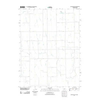
2011 Map of Beaver City SE
USGS Topo · Published 2011About this map
Sappa Creek meanders broadly across this high plains landscape on the border of Nebraska and Kansas, defining a drainage pattern that dictates the local road network. In the northern reaches, the Campbell Dam contains the waters of the Campbell Reservoir, a significant water resource for this agrarian region. The terrain is characterized by a series of north-south drainage features, including Dry Creek and a portion of Beaver Creek in the northwest corner. This 2011 survey illustrates how modern section-line roads, such as Road 705 and Road 431, navigate the undulating elevations between the creek beds, providing a clear view of the rural infrastructure at the start of the 21st century.
Find a feature on this map
23 named features on this map. Tap any name to fly to it.
Don’t see what you’re looking for? This feature index may not catch every label — zoom into the map to look around manually.
Map Details
Editions of this 2011 Beaver City SE Map
This is the sole edition of this map. No revisions or reprints were ever made.
Other maps of this area

1893 · Norton
USGS Topo · 1:125,000

1896 · Arapahoe
USGS Topo · 1:125,000

1898 · Arapahoe
USGS Topo · 1:125,000

1951 · Norton
USGS Topo · 1:62,500

1955 · Grand Island
USGS Topo · 1:250,000

1955 · Beloit
USGS Topo · 1:250,000

1957 · Grand Island
USGS Topo · 1:250,000
1957 · Beaver City SW
USGS Topo · 1:24,000

1957 · Precept
USGS Topo · 1:24,000

1957 · Beaver City SE
USGS Topo · 1:24,000