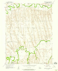
1957 Map of Beaver City SW
USGS Topo · Published 1958About this map
Beaver Creek and Sappa Creek carve the agricultural landscape of south-central Nebraska along the border between Furnas County and Norton County. This mid-century survey documents the rural infrastructure of the Spring Green and Lynden townships during a period of consolidation. While schools like Green Ridge Sch remained active, others had already fallen out of use, such as School No 96 (Abandoned). The northern edge of the map is defined by the Chicago Burlington and Quincy railroad, which follows the curve of the water. Local heritage is deeply rooted in the small country institutions scattered across the sections, including Spring Green Ch and family-linked burial grounds such as Lynden Cem and Rockton Cem.
Find a feature on this map
18 named features on this map. Tap any name to fly to it.
Don’t see what you’re looking for? This feature index may not catch every label — zoom into the map to look around manually.
Map Details
Editions of this 1957 Beaver City SW Map
This is the sole edition of this map. No revisions or reprints were ever made.
Other maps of this area

1893 · Norton
USGS Topo · 1:125,000

1896 · Arapahoe
USGS Topo · 1:125,000

1898 · Arapahoe
USGS Topo · 1:125,000
1951 · Norton
USGS Topo · 1:62,500
1951 · Norcatur
USGS Topo · 1:62,500

1954 · McCook
USGS Topo · 1:250,000

1954 · Goodland
USGS Topo · 1:250,000

1955 · Grand Island
USGS Topo · 1:250,000

1955 · Beloit
USGS Topo · 1:250,000

1956 · Goodland
USGS Topo · 1:250,000