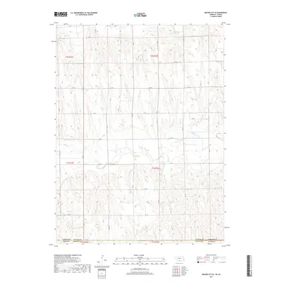
2017 Map of Beaver City SE
USGS Topo · Published 2017About this map
The Nebraska-Kansas state line defines the northern boundary of this territory in Norton County, where the plains give way to a deeply dissected drainage system. Sappa Cr meanders across the central portion of the landscape, while the northern reaches are marked by the presence of Beaver Cr and the Campbell Reservoir. This 2017 survey reveals a highly organized township and range system, with a precise grid of rural roads such as Rd 710 and Rd 702 providing access to the agricultural parcels. The terrain is characterized by intricate contouring that illustrates the many small draws and coulees feeding into Dry Cr, showcasing a landscape shaped by persistent water erosion in a semi-arid region. Researchers can observe the intersection of Furnas and Norton Counties, illustrating the administrative transition between the two states.
Find a feature on this map
21 named features on this map. Tap any name to fly to it.
Don’t see what you’re looking for? This feature index may not catch every label — zoom into the map to look around manually.
Map Details
Editions of this 2017 Beaver City SE Map
This is the sole edition of this map. No revisions or reprints were ever made.
Other maps of this area

1893 · Norton
USGS Topo · 1:125,000

1896 · Arapahoe
USGS Topo · 1:125,000

1898 · Arapahoe
USGS Topo · 1:125,000

1951 · Norton
USGS Topo · 1:62,500

1955 · Grand Island
USGS Topo · 1:250,000

1955 · Beloit
USGS Topo · 1:250,000

1957 · Grand Island
USGS Topo · 1:250,000
1957 · Beaver City SW
USGS Topo · 1:24,000

1957 · Precept
USGS Topo · 1:24,000

1957 · Beaver City SE
USGS Topo · 1:24,000