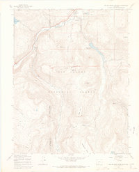
1967 Map of Beaver Creek Reservoir
USGS Topo · Published 1970About this map
The South Fork Rio Grande carves through this high-altitude landscape of the Rio Grande National Forest, illustrating a mid-century period focused on water management and forest recreation. Centered on Beaver Creek Reservoir, the map details a network of drainage systems including Beaver Creek and the Million Reservoir near the northern boundary. The presence of several public sites like the Highway Spring Campground, Beaver Creek Campground, and the Beaver Creek Youth Camp points to the development of the area for seasonal use by the 1960s.
Find a feature on this map
41 named features on this map. Tap any name to fly to it.
Don’t see what you’re looking for? This feature index may not catch every label — zoom into the map to look around manually.
Map Details
Editions of this 1967 Beaver Creek Reservoir Map
3 editions found
Other maps of this area

1913 · Summitville
USGS Topo · 1:125,000

1914 · Creede
USGS Topo · 1:125,000

1915 · Summitville
USGS Topo · 1:125,000

1916 · Creede
USGS Topo · 1:125,000

1945 · Durango
USGS Topo · 1:250,000

1953 · Durango
USGS Topo · 1:250,000

1954 · Durango
USGS Topo · 1:250,000

1957 · Wolf Creek Pass
USGS Topo · 1:62,500

1957 · Spar City
USGS Topo · 1:62,500

1961 · Durango
USGS Topo · 1:250,000