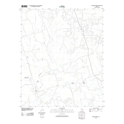
2010 Map of Beaver Creek
USGS Topo · Published 2010About this map
The Electra Oil Field and Consolidated Oil Field define the industrial footprint of this North Texas landscape, where energy extraction and cattle ranching have long coexisted. Situated in Wichita County, the terrain is shaped by the winding course of Beaver Creek and its many tributaries, including Rough Creek and Sunflower Creek. The presence of the Waggoner Ranch Lake Number 6 Dam signifies the importance of water management on the historic ranchlands that dominate this region. Local history and genealogy are preserved at the Ronda Cemetery and Beaver Creek Cemetery, while the Beaver Creek Bridge serves as a key crossing point for local transport. Notable landmarks such as Potato Hill and Steinman Hollow break the horizon, providing orientation for those tracing the network of ranch roads like Turkey Creek Rd and Boosters Station Rd.
Find a feature on this map
27 named features on this map. Tap any name to fly to it.
Don’t see what you’re looking for? This feature index may not catch every label — zoom into the map to look around manually.
Map Details
Editions of this 2010 Beaver Creek Map
This is the sole edition of this map. No revisions or reprints were ever made.
Other maps of this area

1915 · Barwise School
USGS Topo · 1:24,000

1916 · Electra
USGS Topo · 1:24,000

1916 · Fowlkes
USGS Topo · 1:24,000

1917 · Beaver Creek
USGS Topo · 1:24,000

1918 · Electra
USGS Topo · 1:31,680

1918 · Barwise School
USGS Topo · 1:31,680

1919 · Fowlkes
USGS Topo · 1:31,680

1920 · Beaver Creek
USGS Topo · 1:31,680

1954 · Wichita Falls
USGS Topo · 1:250,000

1955 · Lawton
USGS Topo · 1:250,000