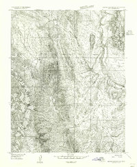
1954 Map of Beaver Dam Mts NE
USGS Topo · Published 1956About this map
The Shivwits Indian Reservation Boundary dominates the eastern half of this 1954 landscape, reflecting the federal land management and tribal sovereignty in Washington County during the mid-twentieth century. The settlement of Shivwits sits along the Santa Clara River, where a small Cem and a Gravel Pit indicate the local community's essential infrastructure and activities. This preliminary survey emphasizes the arid hydrology of the region, marked by intermittent water sources like Jackson Springs and Camp Spring, as well as several man-made Reservoirs and small Res catchments. The topography rises toward the north and west, away from the Santa Clara Bench, as the terrain transitions into the steep relief of Whitmore Canyon. The mapping of these remote water points and simple road tracks provides a snapshot of a high-desert environment before modern development and expansion.
Find a feature on this map
14 named features on this map. Tap any name to fly to it.
Don’t see what you’re looking for? This feature index may not catch every label — zoom into the map to look around manually.
Map Details
Editions of this 1954 Beaver Dam Mts NE Map
2 editions found
Other maps of this area

1885 · St. George
USGS Topo · 1:250,000

1891 · St. George
USGS Topo · 1:250,000

1953 · Cedar City
USGS Topo · 1:250,000

1954 · Beaver Dam Mts NE
USGS Topo · 1:24,000

1954 · Gunlock
USGS Topo · 1:24,000

1954 · Beaver Dam Mts SE
USGS Topo · 1:24,000

1954 · St. George
USGS Topo · 1:62,500

1956 · St. George NW
USGS Topo · 1:24,000
1956 · St. George SW
USGS Topo · 1:24,000

1958 · Cedar City
USGS Topo · 1:250,000