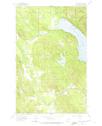
1962 Map of Beaver Lake
USGS Topo · Published 1974About this map
Whitefish Lake dominates the eastern edge of this landscape, its shoreline marked by points such as Eagle Point and Mackinaw Point. The Great Northern railroad cuts through the terrain, following the valley of the Stillwater River and connecting early settlements like Benson and Vista. This 1962 field-checked survey highlights a transition between the Stillwater State Forest and the Flathead National Forest, where timber and water resources defined local life. Small lakes and mountain features are scattered throughout, including the family-named Thornberg Lake and the prominent Lion Mountain. At the southern end of the sheet, the junction at Twin Bridges and the open area of Round Prairie suggest the importance of the river crossings and early mountain roadways like Blanchard Lake Road for local commerce and navigation during the mid-century era.
Find a feature on this map
78 named features on this map. Tap any name to fly to it.
Don’t see what you’re looking for? This feature index may not catch every label — zoom into the map to look around manually.
Map Details
Editions of this 1962 Beaver Lake Map
Other maps of this area

1906 · Kintla Lakes
USGS Topo · 1:125,000

1913 · Stryker
USGS Topo · 1:125,000

1916 · Stryker
USGS Topo · 1:125,000

1938 · Kintla Lakes
USGS Topo · 1:125,000

1943 · Kalispell
USGS Topo · 1:125,000

1957 · Kalispell
USGS Topo · 1:250,000

1960 · Kalispell
USGS Topo · 1:250,000

1961 · Kalispell
USGS Topo · 1:250,000

1962 · Rose Crossing
USGS Topo · 1:24,000

1962 · Beaver Lake
USGS Topo · 1:24,000