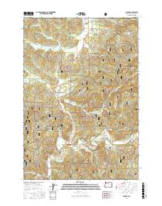
2017 Map of Beaver
USGS Topo · Published 2017About this map
Beaver and Pleasant Valley sit as the primary hubs in this Oregon coastal range survey, where the valley floor topography meets the dense timberlands of the Siuslaw National Forest. The landscape is defined by the winding course of the Nestucca River and the Tillamook River, which are fed by a complex web of tributaries including N Beaver Cr and Wolf Creek. This area shows a deep reliance on the forest road system, with numerous National Forest Development roads like Nat For Dev Rd 8171 carving through the steep terrain to reach remote water bodies like Battle Lake. Locally named features such as Davidson Spring and Trobough Spring offer clues to the importance of natural water sources for the small settlements of Hemlock and Beaver. The presence of Munson Creek Falls in the northeast corner highlights the dramatic vertical changes typical of this part of Tillamook County.
Find a feature on this map
67 named features on this map. Tap any name to fly to it.
Don’t see what you’re looking for? This feature index may not catch every label — zoom into the map to look around manually.
Map Details
Editions of this 2017 Beaver Map
This is the sole edition of this map. No revisions or reprints were ever made.
Other maps of this area

1941 · Nestucca Bay
USGS Topo · 1:62,500

1942 · Ginger Peak
USGS Topo · 1:62,500

1942 · Spirit Mtn
USGS Topo · 1:62,500

1942 · Nestucca Bay
USGS Topo · 1:62,500

1942 · Tillamook
USGS Topo · 1:62,500

1948 · Vancouver
USGS Topo · 1:250,000

1950 · Vancouver
USGS Topo · 1:250,000

1950 · Vancouver
USGS Topo · 1:250,000

1955 · Hebo
USGS Topo · 1:62,500

1955 · Blaine
USGS Topo · 1:62,500