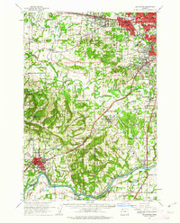
1961 Map of Beaverton
USGS Topo · Published 1963About this map
Beaverton and the surrounding valley communities of Aloha, Tigard, and Tualatin appear here during a period of significant suburban expansion in the early 1960s. The northern portion of the map is dominated by the dense residential grids of West Slope, Raleigh Hills, and Garden Home, while the southern reaches remain predominantly agricultural. The Tualatin River meanders through the center of the sheet, providing a natural drainage for the lowlands of Onion Flat.
Find a feature on this map
108 named features on this map. Tap any name to fly to it.
Don’t see what you’re looking for? This feature index may not catch every label — zoom into the map to look around manually.
Map Details
Editions of this 1961 Beaverton Map
This is the sole edition of this map. No revisions or reprints were ever made.
Other maps of this area

1897 · Portland
USGS Topo · 1:62,500

1905 · Portland
USGS Topo · 1:62,500

1914 · Oregon City
USGS Topo · 1:62,500

1915 · Hillsboro
USGS Topo · 1:62,500

1916 · Tualatin
USGS Topo · 1:62,500

1918 · Hillsboro
USGS Topo · 1:62,500

1923 · Mount Angel
USGS Topo · 1:62,500

1924 · Mc Minnville
USGS Topo · 1:48,000

1926 · Mc Minnville
USGS Topo · 1:62,500

1939 · Molalla
USGS Topo · 1:62,500