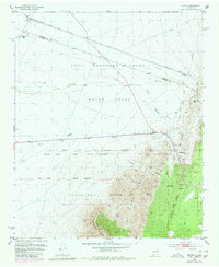
1952 Map of Becker
USGS Topo · Published 1980About this map
The Atchison Topeka and Santa Fe railroad cuts across this high desert landscape, serving the small settlement of Becker near the Valencia and Socorro county line. The geography is defined by a complex overlay of Spanish land grants, including the Casa Colorada Grant, Belen Grant, and Sevilleta Grant. This 1952 survey shows the transition from ranching operations like the West and Pyle Ranch and Goat Ranch to the establishment of the Sevilleta National Wildlife Refuge. To the south, the terrain rises sharply into the Los Pinos Mountains and the prominent Whiteface Mountain. Industrial activity is noted at the San Sais Quarry, while remote infrastructure is evidenced by scattered Landing Strips and a network of pipelines crossing Abo Arroyo and Pino Draw.
Find a feature on this map
26 named features on this map. Tap any name to fly to it.
Don’t see what you’re looking for? This feature index may not catch every label — zoom into the map to look around manually.
Map Details
Editions of this 1952 Becker Map
2 editions found
Other maps of this area

1916 · La Joya
USGS Topo · 1:125,000

1917 · Estancia
USGS Topo · 1:125,000

1952 · Tome SE
USGS Topo · 1:24,000

1952 · Black Butte
USGS Topo · 1:24,000

1952 · Turn
USGS Topo · 1:24,000

1952 · Becker SW
USGS Topo · 1:24,000

1952 · Becker
USGS Topo · 1:24,000

1952 · Cerro Montoso
USGS Topo · 1:24,000

1954 · Torreon
USGS Topo · 1:62,500

1954 · Socorro
USGS Topo · 1:250,000