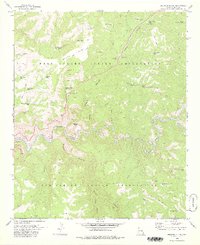
1978 Map of Beckers Butte
USGS Topo · Published 1978About this map
The Salt River carves a deep boundary through this Central Arizona landscape, separating the Fort Apache Indian Reservation to the north from the San Carlos Indian Reservation to the south. This 1970s topographic record shows a land defined by its water sources, with family-named or descriptive landmarks like Ike Clyde Tank, Bohee Tank, and Flying V Spring supporting life and livestock in the arid terrain. The high ground of Black Mesa and the prominent Beckers Butte overlook a complex network of drainages including Walnut Canyon and Sawmill Canyon. The presence of a Gaging Station and a Prospect along the river corridor reflects the vital management of water and the search for mineral resources. A primitive transportation network consisting of a Jeep Trail, Trail, and Pack Trail highlights the difficulty of moving through this canyon-cut geography.
Find a feature on this map
48 named features on this map. Tap any name to fly to it.
Don’t see what you’re looking for? This feature index may not catch every label — zoom into the map to look around manually.
Map Details
Editions of this 1978 Beckers Butte Map
This is the sole edition of this map. No revisions or reprints were ever made.
Other maps of this area

1922 · Chrysotile
USGS Topo · 1:125,000

1946 · Blue House Mtn
USGS Topo · 1:62,500

1951 · Blue House Mtn
USGS Topo · 1:62,500

1954 · Mesa
USGS Topo · 1:250,000

1957 · Mesa
USGS Topo · 1:250,000

1958 · Mesa
USGS Topo · 1:250,000

1960 · Mesa
USGS Topo · 1:250,000

1964 · Mesa
USGS Topo · 1:250,000

1966 · Brushy Canyon
USGS Topo · 1:24,000

1966 · Popcorn Canyon
USGS Topo · 1:24,000