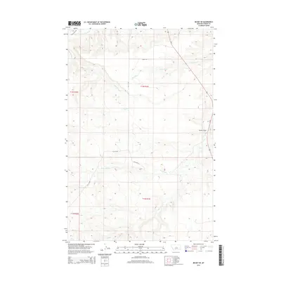
2014 Map of Becket NE
USGS Topo · Published 2014About this map
Beaver Ball Cr and the Dry Fork carve through this central Montana landscape within Fergus County, reflecting a classic Western drainage pattern defined by seasonal coulees and creek forks. The area is marked by a network of rural routes that trace the topography, including the descriptively named Dead Horse Ln and the Tyler Cutoff. In the northern section, Bench Rd follows the higher ground between N Fork Elk Cr and the Dry Fork, while the northeastern corner is defined by the descent into Butler Coulee. This 2014 survey by the U.S. Geological Survey preserves the specific road alignments and water boundaries of the early 21st century, illustrating how ranching and land management access routes like Forest Grove Rd navigate the transition between the watershed of S Fork McDonald Cr and the various branches of Elk Cr.
Find a feature on this map
15 named features on this map. Tap any name to fly to it.
Don’t see what you’re looking for? This feature index may not catch every label — zoom into the map to look around manually.
Map Details
Editions of this 2014 Becket NE Map
This is the sole edition of this map. No revisions or reprints were ever made.
Other maps of this area

1954 · Roundup
USGS Topo · 1:250,000

1954 · Lewistown
USGS Topo · 1:250,000

1958 · Roundup
USGS Topo · 1:250,000

1959 · Lewistown
USGS Topo · 1:250,000

1986 · Tyler
USGS Topo · 1:24,000

1986 · Briggs Coulee
USGS Topo · 1:24,000

1986 · Pike Creek Hills West
USGS Topo · 1:24,000
1986 · Grass Range
USGS Topo · 1:24,000
1986 · Fish Dam
USGS Topo · 1:24,000

1986 · Milk Springs
USGS Topo · 1:24,000