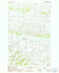
1986 Map of Fish Dam
USGS Topo · Published 1986About this map
Ayers Ranch Colony serves as a primary point of human settlement in this central Montana landscape, situated near the confluence of several vital watercourses. The drainage patterns of Alkali Creek, Chippewa Creek, and Fords Creek define the undulating terrain of Fergus County, while the North Fork Mc Donald Creek flows past the small settlement. An adjacent Cem and Grain Bins suggest the long-standing agricultural and community roots of the ranching area. Evidence of former industrial infrastructure is visible through the Old Railroad Grade that cuts across the land, marking a time when rail transport connected these reaches of the plains. Local landmarks like the Fish Dam provide specific points of interest for those studying the water management and rural development of the region during the mid-1980s.
Find a feature on this map
14 named features on this map. Tap any name to fly to it.
Don’t see what you’re looking for? This feature index may not catch every label — zoom into the map to look around manually.
Map Details
Editions of this 1986 Fish Dam Map
This is the sole edition of this map. No revisions or reprints were ever made.
Other maps of this area

1889 · Big Snowy Mountain
USGS Topo · 1:250,000

1893 · Big Snowy Mountain
USGS Topo · 1:250,000

1941 · Judith Peak
USGS Topo · 1:62,500

1944 · Judith Peak
USGS Topo · 1:62,500

1954 · Roundup
USGS Topo · 1:250,000

1954 · Lewistown
USGS Topo · 1:250,000

1958 · Roundup
USGS Topo · 1:250,000

1959 · Lewistown
USGS Topo · 1:250,000

1970 · Forestgrove
USGS Topo · 1:24,000

1978 · Lewistown
USGS Topo · 1:100,000