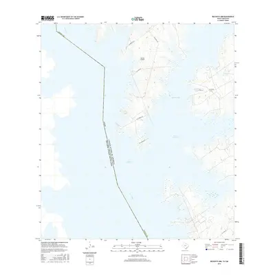
2016 Map of Beckwith Arm
USGS Topo · Published 2016About this map
Falcon Reservoir dominates this South Texas landscape, where the waters of the impounded Rio Grande define the international boundary between the United States and Mexico. This survey illustrates the intricate, branching shoreline of the Beckwith Arm and the surrounding arid terrain of Zapata County. The map reveals a network of rural routes and ranch roads, such as Alejandrejas Rd and Cox Camp Rd, that navigate the ridges above Bronco Canyon. Inland water features like Juan Vela Lake and various smaller tanks punctuate the brush country, indicating the essential role of water management in this borderland environment. The topographic detail captures the transition from the high, dissected plateaus down to the submerged former river valley, providing a clear view of the region's geographic character before and after the reservoir's reach.
Find a feature on this map
14 named features on this map. Tap any name to fly to it.
Don’t see what you’re looking for? This feature index may not catch every label — zoom into the map to look around manually.
Map Details
Editions of this 2016 Beckwith Arm Map
This is the sole edition of this map. No revisions or reprints were ever made.
Other maps of this area

1938 · Falcon
USGS Topo · 1:62,500

1949 · Mc Allen
USGS Topo · 1:250,000

1954 · McAllen
USGS Topo · 1:250,000

1956 · Zapata
USGS Topo · 1:62,500

1956 · Arroyo Clareno
USGS Topo · 1:62,500

1957 · Mc Allen
USGS Topo · 1:250,000

1962 · McAllen
USGS Topo · 1:250,000

1965 · Salineno
USGS Topo · 1:24,000
1965 · Falcon Village
USGS Topo · 1:24,000

1965 · Lopeno
USGS Topo · 1:24,000