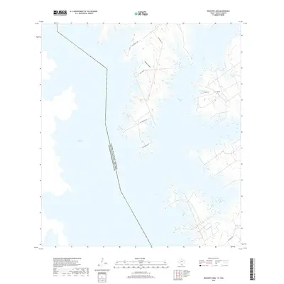
2019 Map of Beckwith Arm
USGS Topo · Published 2019About this map
The international boundary between the United States of America and Mexico cuts directly through the waters of the Falcon Reservoir in this South Texas borderland. The landscape is defined by the labyrinthine shoreline of the Beckwith Arm, where numerous peninsulas and inlets create a complex interface between water and land. Several local roads, including Alejandrejas Rd, Cox Camp Rd, and El Tigre Rd, provide access to the remote fingers of land that extend into the reservoir. Further inland to the east, the terrain transitions into more arid brush country, marked by the drainage of Bronco Canyon and small bodies of water like Juan Vela Lake. The map illustrates the 21st-century state of this managed waterway and the network of access roads serving the Zapata County ranchlands.
Find a feature on this map
11 named features on this map. Tap any name to fly to it.
Don’t see what you’re looking for? This feature index may not catch every label — zoom into the map to look around manually.
Map Details
Editions of this 2019 Beckwith Arm Map
This is the sole edition of this map. No revisions or reprints were ever made.
Other maps of this area

1938 · Falcon
USGS Topo · 1:62,500

1949 · Mc Allen
USGS Topo · 1:250,000

1954 · McAllen
USGS Topo · 1:250,000

1956 · Zapata
USGS Topo · 1:62,500

1956 · Arroyo Clareno
USGS Topo · 1:62,500

1957 · Mc Allen
USGS Topo · 1:250,000

1962 · McAllen
USGS Topo · 1:250,000

1965 · Salineno
USGS Topo · 1:24,000
1965 · Falcon Village
USGS Topo · 1:24,000

1965 · Lopeno
USGS Topo · 1:24,000