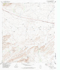
1983 Map of Beckwith Hills
USGS Topo · Published 1984About this map
Peña Colorado Creek flows through this corner of the Trans-Pecos, a landscape defined by ranching infrastructure and the tracks of the Southern Pacific railroad. The map documents a sparse but vital network of water sources necessary for desert survival, including named windmills like the Negley Trap Windmill and Skinner Windmill, alongside scattered holdings such as the Arnold Ranch. Near the small rail siding of Lenox, the topography rises into the Payne Hills and Beckwith Hills, where deep drainages like Alsate Canyon and Little Road Canyon cut through the limestone terrain.
Find a feature on this map
33 named features on this map. Tap any name to fly to it.
Don’t see what you’re looking for? This feature index may not catch every label — zoom into the map to look around manually.
Map Details
Editions of this 1983 Beckwith Hills Map
This is the sole edition of this map. No revisions or reprints were ever made.
Other maps of this area

1920 · Monument Spring
USGS Topo · 1:62,500

1920 · Marathon
USGS Topo · 1:62,500

1921 · Monument Spring
USGS Topo · 1:62,500

1921 · Marathon
USGS Topo · 1:62,500

1923 · Hess Canyon
USGS Topo · 1:62,500

1923 · Altuda
USGS Topo · 1:62,500

1954 · Fort Stockton
USGS Topo · 1:250,000

1958 · Fort Stockton
USGS Topo · 1:250,000

1973 · Fort Stockton
USGS Topo · 1:250,000
1983 · Dugout Mountain
USGS Topo · 1:24,000