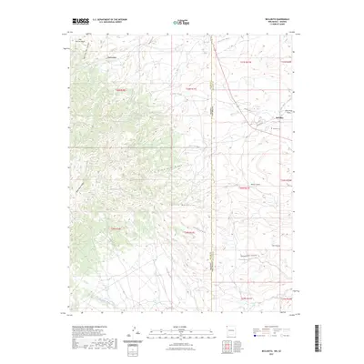
2023 Map of Beclabito
USGS Topo · Published 2023About this map
The Beclabito settlement sits on the eastern edge of this landscape, positioned where the high desert floor meets the rising slopes of the Carrizo Mountains. This modern topographic survey highlights a transition from the rugged drainage systems of the Blackrock Wash and Cottonwood Wash to the prominent geological features of the mountain foothills. Local history and genealogy interest is anchored by the Beclabito Cem and nearby water sources like Beclabito Spring and Black Rock Canyon Spring, which have likely supported inhabitants in this arid environment for generations. The terrain is defined by dramatic elevation changes, notably at Black Rock Point and along the Black Rock Ridge, while the northwestern corner is marked by Twin Falls. Transportation routes, including Indian Rte 5111 and 64, connect the area across the border between Apache and San Juan counties, bridging the line between Arizona and New Mexico.
Find a feature on this map
36 named features on this map. Tap any name to fly to it.
Don’t see what you’re looking for? This feature index may not catch every label — zoom into the map to look around manually.
Map Details
Editions of this 2023 Beclabito Map
This is the sole edition of this map. No revisions or reprints were ever made.
Other maps of this area

1889 · Chaco
USGS Topo · 1:250,000

1892 · Chaco
USGS Topo · 1:250,000

1892 · Canyon De Chelly
USGS Topo · 1:250,000

1934 · Ship Rock
USGS Topo · 1:62,500

1934 · Rattlesnake
USGS Topo · 1:62,500

1937 · Ship Rock
USGS Topo · 1:62,500

1937 · Rattlesnake
USGS Topo · 1:62,500

1953 · Redrock Valley NE
USGS Topo · 1:24,000

1953 · Pastora Peak SW
USGS Topo · 1:24,000

1953 · Pastora Peak NW
USGS Topo · 1:24,000
Featured Places
- Shiprock Agency
- Beclabito, Shiprock Agency
- Beclabito, Shiprock Agency
- Twin Falls, Shiprock Agency
- San Juan County, NM