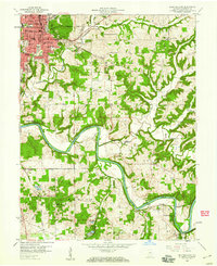
1958 Map of Bedford East
USGS Topo · Published 1960About this map
White River East Fork meanders through the southern half of this 1958 survey, defining the industrial and agricultural landscape of Lawrence County. The city of Bedford serves as the regional hub in the northwest, showing a dense grid of streets, schools like Madden Sch and Stalker Sch, and the central Courthouse. Transportation is dominated by the intersecting routes of the Chicago Indianapolis and Louisville (Monon) and the Chicago Milwaukee St Paul and Pacific railroads, which facilitated the movement of goods and stone from local Quarry sites. Smaller rural settlements such as Buddha, Yockey, and Rabbitville dot the outlying townships of Shawswick and Guthrie. Notable landmarks including the Bedford Municipal Airport and the Otis Park Golf Course suggest a growing mid-century community balancing traditional industry with modern civic recreation.
Find a feature on this map
54 named features on this map. Tap any name to fly to it.
Don’t see what you’re looking for? This feature index may not catch every label — zoom into the map to look around manually.
Map Details
Editions of this 1958 Bedford East Map
2 editions found
Other maps of this area

1934 · Bedford
USGS Topo · 1:48,000

1935 · Oolitic
USGS Topo · 1:48,000

1937 · Bedford
USGS Topo · 1:62,500

1942 · Oolitic
USGS Topo · 1:62,500

1949 · Georgia
USGS Topo · 1:24,000

1950 · Mitchell
USGS Topo · 1:24,000

1951 · Georgia
USGS Topo · 1:24,000

1956 · Vincennes
USGS Topo · 1:250,000

1957 · Vincennes
USGS Topo · 1:250,000
1957 · Oolitic
USGS Topo · 1:24,000