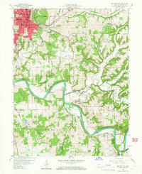
1958 Map of Bedford East
USGS Topo · Published 1966About this map
Bedford serves as the industrial and civic anchor of this mid-century Lawrence County landscape, where the limestone heritage of southern Indiana is evidenced by numerous quarries dotting the terrain. The city is a hub of transit and infrastructure, featuring the Dunn Memorial Hospital, Bedford Municipal Airport, and a dense network of education and religion, including St Vincent De Paul Sch and several public institutions. The rural surroundings in Shawswick and Guthrie townships reveal a more dispersed settlement pattern, with family cemeteries like Sheeks Cem and Erwin Cem and small communities such as Buddha and Rivervale. The winding course of the South Fork White River dictates the topography of the southern portion of the quadrangle, flanked by the Baltimore and Ohio Railroad and the Monon line, reflecting a period when rail transport was still vital to the local quarrying and agricultural economy.
Find a feature on this map
49 named features on this map. Tap any name to fly to it.
Don’t see what you’re looking for? This feature index may not catch every label — zoom into the map to look around manually.
Map Details
Editions of this 1958 Bedford East Map
2 editions found
Other maps of this area

1934 · Bedford
USGS Topo · 1:48,000

1935 · Oolitic
USGS Topo · 1:48,000

1937 · Bedford
USGS Topo · 1:62,500

1942 · Oolitic
USGS Topo · 1:62,500

1949 · Georgia
USGS Topo · 1:24,000

1950 · Mitchell
USGS Topo · 1:24,000

1951 · Georgia
USGS Topo · 1:24,000

1956 · Vincennes
USGS Topo · 1:250,000

1957 · Vincennes
USGS Topo · 1:250,000
1957 · Oolitic
USGS Topo · 1:24,000