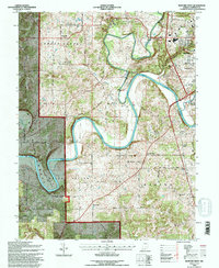
1993 Map of Bedford West
USGS Topo · Published 1996About this map
The East Fork White River carves a dramatic winding course through Lawrence County, creating prominent landforms like Gyger Bend and Horseshoe Bend. In the early 1990s, this landscape was a mix of protected woodlands within the Hoosier National Forest and the industrial outskirts of Bedford. The mapping of townships like Shawswick, Spice Valley, and Marion reveals a rural infrastructure of narrow roads and family burial grounds, such as Bass Cem and Sherwood Cem.
Find a feature on this map
50 named features on this map. Tap any name to fly to it.
Don’t see what you’re looking for? This feature index may not catch every label — zoom into the map to look around manually.
Map Details
Editions of this 1993 Bedford West Map
This is the sole edition of this map. No revisions or reprints were ever made.
Other maps of this area

1934 · Bedford
USGS Topo · 1:48,000

1935 · Oolitic
USGS Topo · 1:48,000

1937 · Bedford
USGS Topo · 1:62,500

1942 · Oolitic
USGS Topo · 1:62,500

1948 · Huron
USGS Topo · 1:24,000

1949 · Georgia
USGS Topo · 1:24,000

1950 · Mitchell
USGS Topo · 1:24,000

1950 · Huron
USGS Topo · 1:24,000

1951 · Georgia
USGS Topo · 1:24,000

1956 · Vincennes
USGS Topo · 1:250,000